Ward’s Stone

Now, at that highest point
on the fells, no trace remains of what
was done so long ago,
but its name has endured.
They call it
the Wardstone.
– Joseph Delaney

What was done so long ago?
Bog feet squelch across the moors.
Black peaty waters know.
Underground streams pour.

Its name has endured.
Sphagnum knows the springy secret
of the one known as the ward
but cannot keep it.

They call it the Wardstone,
say it keeps the fells in place,
some Annuvian monster down.
At the highest point no trace.

This slideshow requires JavaScript.

I’ve lived in Lancashire since I was six but this is the first time I’ve been to Ward’s Stone, the highest fell, made hauntingly legendary by Joseph Delaney in his awesome Wardstone Chronicles.

It’s a wonderful place although not many humans seem to visit. I saw one group of students who gave up after the first few boggy patches and a couple who vanished into the earth at the Queen’s Chair. Somehow, in spite of all the bogs, I didn’t get wet feet. Walking boots are the best invention ever!

For Tonight

I am a shape who shifts
like the costumes of mosses
like the rabbit eyes of trees

Tockholes I

leaping out of my skin
plunging into the dark arms
of underwater trees

Tockholes III

for once knowing beauty and fluidity
as I run down stairs without
missing a single step.

Tockholes IV

I am the waterfall and its deep pool,
the sun reflected and the fear
of loss surrounding him
like the magic of Faerie,
the golden ball,

Tockholes V

the secrets found by bees
crawling into the purple caverns
of foxgloves emerging centuries later
coated in dusty wisdom.

Tockholes VII (copy)

Can it be possible
that I am wide awake
like your rival as you dream
these enchantments

and here, now, even
at midsummer

the aspen trembles
at your name?

SAMSUNG CAMERA PICTURES

*This poem is based on a walk in Tockholes Wood on Midsummer Eve and is addressed to Gwyn, who remains a presence in my life even in his absence from the landscape.

Penwortham Priory and the Rule of Saint Benedict

You wouldn’t know it had ever been there if wasn’t for the street names Priory Lane, Priory Close, Priory Crescent, Monk’s Walk, and the names of Priory Park Care Home and Penwortham Priory High School (where I was educated between 11 and 16 and from where I tried to escape as often as possible!).

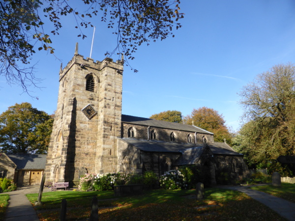
Castle Hill, the pen, the prominent headland, which puts the ‘Pen’ in Penwortham has been the town’s central religious and defensive site for thousands of years. The castle mound remains along with St Mary’s Church and graveyard, but Penwortham Priory and its black-robed monks are long gone.

St Mary's Church

Penwortham Priory was founded in the 1140s when Warin (de) Bussel, a Norman Lord who was the first Baron of Penwortham, transferred St Mary’s Church to the Benedictine abbey of Evesham in Worcestershire. The abbot funded the building of the priory and sent a prior and three monks to serve.

The priory was an ‘obedience’ of Evesham Abbey and had no independence of its own. Because it was replaced with a mansion after the dissolution we do not know what it looked like. Alan Crosby suggests it is was a ‘monastic grange with a chapel… built around a quadrangle in some form of cloister.’

Penworthampriory_authorunknown_wikipedia

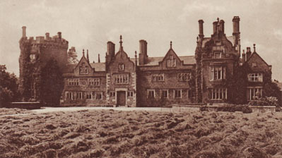
Penwortham Priory rebuilt as a mansion

The priors and monks were often sent from the larger and richer abbey (where there were sixty-seven monks, five nuns, three clerks, and sixty-five servants) as a punishment. This bleak north-western headland, overlooking Penwortham Marsh and the tidal Ribble, must have been cold and wet and probably felt like the end of the world in contrast to Evesham.

We know little about Penwortham’s monks and priors. The priors’ names are listed from Henry in 1159 to Richard Hawkesbury, who withdrew before the dissolution of the priory in 1539. Those whose lives have warranted comment are a ‘good-hearted’ Prior Wilcote who fed his monks up after periodical blood-letting (this disturbingly suggests he was the exception) and a notorious prior called Roger Norris.

Norris was described as ‘a glutton, wine-bibber, and loose-liver’ who could nevertheless through eloquence and courtly manners put on a show of learning. After betraying his brethren at Christ Church, Canterbury, and being imprisoned, he escaped through a sewer. Richard I made him abbot of Evesham and he ‘dissipated its revenues until the monks were reduced to a diet of bread and water… for lack of decent clothing many of them could not appear in the choir or chapter house.’

Norris was eventually removed from his position and instead made prior of Penwortham where he continued in his excesses, being deposed then reinstated until 1223, when he died refusing to be reconciled to the abbot of Evesham and withholding certain revenues that belonged to the abbey.

Although there are no records of the everyday lives of the monks of Penwortham Priory we can gain insights into their routine and religious values by examining the life and rule of St Benedict and the Benedictine movement.

***

Benedict was born in Nursia, in Italy, in 480. He was sent to Rome to study but, disappointed by the immoral lives of his companions, he decided to leave and become a hermit. He departed for Enfide and, on his way through a narrow valley, met with Romanus of Subiaco, who lived in a monastery on the cliff. Subiaco gave Benedict his monk’s habit and counselled him to live in the cave beneath the cliff.

423px-Meister_von_Meßkirch_002

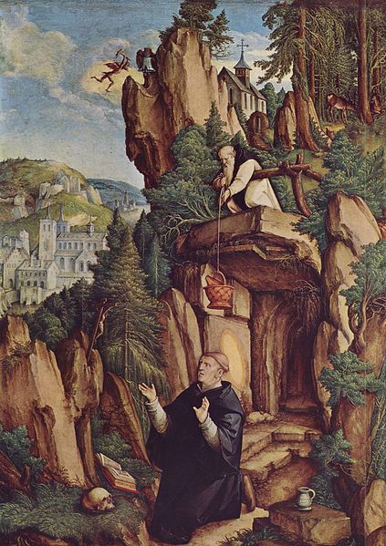
Between the summit and the clear blue lake beneath Benedict lived alone for three years with Romanus bringing him food. Afterwards, when the monks of another nearby monastery asked him to become their abbot, he reluctantly agreed, but because of their ‘diverse manners’ they did not get on and attempted to poison him. Benedict prayed a blessing over the poisoned cup and it shattered.

When he returned to his cave a jealous priest called Florentius tried poisoning him with poisoned bread, but he prayed another blessing and a raven flew down and took the loaf away. When Benedict attracted his own followers Florentius tried to seduce them with prostitutes and failed.

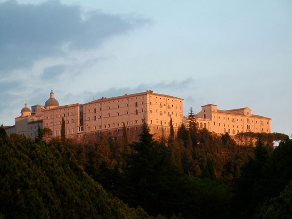
To avoid further persecution Benedict left Subiaco and established 12 monasteries nearby. In 530 he founded the monastery of Monte Cassino where he died of a fever on the 21st of March in 543 or 547.

800px-Monte_Cassino_Opactwo_1

Benedict originally wrote his Rule for autonomous self-governing communities. Its 56 chapters form guidelines regulating the daily offices of prayer, work, sleep, meals, clothing, possessions, and behaviour.

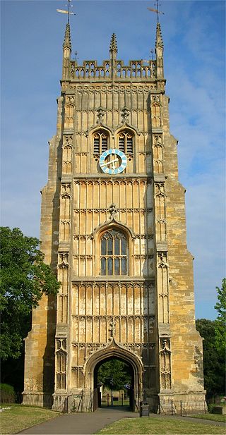
After his death Benedictine monasticism grew rapidly in popularity throughout Europe and was brought to England by Saint Augustine, who was sent by Pope Gregory I to Christianise the pagan Anglo-Saxons. He founded the first Benedictine monastery in Canterbury and became its abbot in 597.

Saint Wilfrid, the first English Christian to visit Rome in 658, enforced the Roman method for calculating Easter and introduced the Rule of Saint Benedict in his monasteries at Ripon and Hexham. Wilfrid was granted lands ‘iuxta Rippel’ ‘by the Ribble’ at Preston (Preosta Tun ‘Priest Town’) across from Penwortham. The parish church was dedicated him and he became the town’s patron saint. However, there is no evidence that Wilfrid set up any Benedictine monasteries in the local area.

Evesham Abbey was built by St Egwin between 700 and 710 after a swineherd called Eog experienced a vision of the Virgin Mary. Thus its link to St Mary’s in Penwortham is of interest.

320px-Evesham_Abbey_Bell_Tower

The Order of Saint Benedict was founded in 910 by the abbot of Cluny and this is when it became centralised.

152 Benedictine monasteries and 52 nunneries were established across England. They became important seats of learning and literature and sanctuaries for holy relics and works of art. It was partly because of their wealth and power that King Henry VIII dissolved them between 1536 and 1541.

***

From the Rule of St Benedict we can guess the monks of Penwortham performed eight offices of prayer a day: Matins (midnight), Lauds (dawn), Prime (early morning), Terce (mid-morning), Sext (midday), None (mid-afternoon), Vespers (evening), Compline (bedtime). They would have performed no less than five hours of manual labour. Eating the flesh of four-legged animals was banned. The usual fare was a pound of bread and quarter litre of wine (which I imagine was supplemented with seasonal fruit and vegetables and fish from the fisheries and panneries). They lived by strict vows of obedience, stability, and chastity, and the renunciation of all worldly possessions.

I have often wondered what led them to becoming monks. The call of God? The promise of a life rich in religion and art? The guarantee of safety and stability in a harsh and war-torn world? Did they find God, Jesus, Mary, here on this lonely hill as the rain poured and fires burnt low in the grates?

Did any of them sense the presence of the ancient goddess of the hill, the marsh, the healing well, or the otherworldly god and his spirits who would later be seen marching in a fairy funeral procession?

As an awenydd I can understand the appeal of leading a life of prayer in community in devotion to one’s god(s). However, I cannot imagine wanting to be part of an Order founded on the elimination of a multitude of local variants of Christianity, which in turn eliminated a multitude of local variants of paganism.

When I visit the sites of priories and abbeys I often feel a combination of yearning and sorrow. The yearning to be a part of something big, to participate in shared devotion, to find and wonder in the same god. Yet I also feel saddened by the weight of destruction that has brought this hegemonic religion about. All the gods and spirits and the diverse sets of beliefs that have been crushed, wiped out.

Whilst I long for a devotional community I could never join a Christian monastery or a pagan, polytheistic or druidic order that is based on or even inspired by Christian monastic ideals and principles as it these very things that have cast out and demonised the gods and spirits within the landscape.

Thus I remain a solitary devotee of those deities within the land, beneath the church, beneath the roads and street names that mark where the feet of monks once trod and where they tread no longer.

Monks Walk


SOURCES

Alan Crosby, Penwortham in the Past, Carnegie Press, (1988)
Saint Benedict, Rev. Verheyen Boniface (transl), The Rule of Saint Benedict, (Christian Classics Ethereal Library, 1923)
William Farrer and J Brownbill (ed.), ‘Houses of Benedictine monks: The priory of Penwortham’, A History of the County of Lancaster: Volume 2, (London, 1908)
Benedict of Nursia, Wikipedia

Lost Wells and Watercourses of Priest Town

A display created for the Precarious Landscapes Exhibition

Introduction

The Old English name of Preston, Preosta Tūn, ‘Priest Town’, suggests it was once considered an especially sacred place. I believe this was because of its numerous watercourses and natural springs. The surrounding area has been inhabited since the Mesolithic period (10,000 years ago). The Ribble was venerated by the ancient Britons as Belisama, ‘Most Shining One’, a mighty goddess. The spirits of each spring and well, offering nourishment and healing, would have been worshipped for thousands of years.

When Christianity was introduced the rivers were adopted for baptisms and the wells were rededicated to saints. Priest Town was founded in 670 when lands iuxta Rippel were granted to St Wilfrid’s Abbey at Ripon. Wilfrid was Preston’s patron saint. In the 12th century priories formed around the wells at Tulketh and Penwortham and a friary around Lady Well in Preston. After the dissolution of the monasteries the wells continued to be venerated and visited by pilgrims seeking cleansing and healing. For those of a less religious nature their medicinal qualities were valued.

It was not until the industrial period, when all that was sacred was profaned, the waters lost their sanctity. The brooks were culverted and the Ribble moved from its original course during the building of Riversway Docklands. The introduction of piped water and extensive engineering works to build the canal and docks caused Preston’s wells to run dry. In two hundred years the complex network of watercourses that nourished local people physically and spiritually since the last Ice Age was displaced and destroyed.

As climate change brings the threat of floods we are left in a precarious position with only the technology that engineered our crisis to rely on. And our prayers to Belisama and her daughters. ‘Precarious’ and ‘prayer’ share their root in the Latin precarius, ‘obtained by treaty’. If we wish to survive these precarious times our treaty with our sacred watercourses must be renewed.

Wells

Lady Well

Lady Well was close to Preston Franciscan Friary. Its location off Marsh Lane, in the Maudlands area, and proximity to the leper hospital dedicated to St Mary Magdalen, suggest its Lady was the Magdalen. The Grey Friars (who gave their name to Friargate and the Grey Friar’s pub) lived by begging, saying masses, and praying for the souls of the wealthy. After the friary was dissolved in 1539 the devout continued to venerate the well. In 1794 the digging of the Lancaster Canal altered the water table and it dried up. Excavations for the Legacy Hotel in 2007 revealed the location of the friary and well. It gives its name to Lady Well Street and lies beneath the car park of Brunel Court.

Site of Lady Well sm

Spa Well

Spa Well was located on Spring Row in the Spa Brow valley where crystal springs were abundant. Nearby was Spa Bath, an open-air cold-water bath constructed in 1708, which survived for 150 years (Cold Bath Street led to it). Spa Well possessed strengthening qualities and children were taken to it. Preston Waterworks Company formed in 1832 and built the Grimsargh reservoirs in 1835. When piped water was introduced, Preston’s wells and springs were drained and covered. Spa Well was the last. Its site lies east of Spa Street on the bank behind the gardens of Wellington Terrace.

Site of Spa Well sm

Ashton Quays Well

Ashton Quays Well was situated on the north bank of the Ribble at Marsh End and possessed medicinal qualities. Like Spa Well it was probably drained and covered when piped water was introduced. Another factor in its demise was the movement of the Ribble from Watery Lane to its current position near to Castle Hill. Its site is on the north of Watery Lane to the left of Key Line Civils and Drainage.

Site of Ashton Quays Well II

The Dolphin Fountain

The Dolphin Fountain, set in a stone alcove built in the 1860s on Avenham Park in Preston, was served by pipes from a nearby spring that never ran dry and was reputed to cure eye ailments. It was used until the mid-20th century when the tap and two cups on chains were removed. The alcove remained empty until re-instated in 2011. Oddly, the feature, remodelled from the 19th century, looks more like a sea-serpent than a dolphin. I wonder if it represents a serpentine water spirit? No water flows from the fountain, but it runs from a rock on the left down a channel to a drain.

The Dolphin Fountain II

Main Sprit Weind Well

Near the bottom of Main Sprit Weind was a well frequented by young petticoated ladies who carried water along with milk and butter to the town centre. For this reason this narrow passageway was also called Petticoat Alley. The well had disappeared by 1840, indubitably replaced by piped water.

Site of Main Sprit Weind Well II

Watercourses

The Syke

The Syke (from Old English sīc, ‘small stream, rill), originated as a spring of water at the junction of present-day Queen Street and Grimshaw Street. It flowed from Syke Hill, along what is now Syke Street, supplying the water troughs in Avenham and feeding Avenham Mill. Its course can be traced under Winckley Square, the Fishergate Centre, and the railway station, running parallel to Fishergate before emerging into the Ribble from its culvert south of Fishergate Bridge. It’s said that if you put your ear to the drain at the bottom of Main Sprit Weind it can be heard rushing beneath at times of heavy rain.

Course of the Syke Syke Street II

Swill Brook

Swill Brook’s source lay in present-day Waverley Park in Ribbleton. It entered Preston north of Salmon Street then flowed across London Road, through Larkhill Grounds, down the steep bank which forms part of Frenchwood Knoll Nature Reserve into the Ribble at the Tram Bridge. At the confluence was a washing stead where local women used the fast-flowing water to swill their clothes. This is how Swill Brook got its name. Swill Brook Lane marks the route the washer-women used.

Course of Swill Brook Frenchwood Knoll II

Moor Brook

The Moor Brook began east of present-day Deepdale Road then ran across Preston Moor, feeding Brunswick Place Mill and Brookfield Mill, giving its name to Brook Field Street and the Moor Brook pub. From the car park behind the pub you can see the steepness of its valley. Its course can be traced from Moor Brook Street to Brook House Street (where it fed Brook House Mill) and Greenbank Street. It finally became Swansea Gutter (near Swansea Terraces) at Ashton Quays and entered the Ribble at Watery Lane.

Painting of the Moor Brook on Moor Brook Pub Sign sm

Unnamed Streams

There are two unnamed streams between the Moor Brook and the Syke on the 1774 map of Preston. Keith Johnson mentions that one of them has its source near Bow Lane in a field called Springfield, thus providing the names for Springfield Place and Spring Bank. On a local walk Aidan Turner-Bishop mentioned that the second stream was culverted beneath the Lamb and Packet, but I have not been able to find any further information.

Spring Bank II

The Last Bend in the Ribble

Prior to 1884, when the Ribble was moved south to make way for Riversway Docklands, swinging sharply and artificially left between its concrete training walls, it followed a different course. Curving slowly it passed Victoria Quays (Neptune House is the last reminder) and Ashton Quays at Watery Lane, following present-day Chain Caul Way before joining its natural course at the end of Nelson Way. The remains of the caul – a man-made jetty with a scouring effect – can be seen to this day. Its movement had a detrimental effect on other water sources. The removal of sandstone bedrock shattered the aquifer beneath Castle Hill, causing St Mary’s Well, which was renowned for its healing properties to dry up. The dock silted up by 1981. Its benefits were short lived and came at great cost.

Neptune House Last Bend of the Ribble II

SOURCES

David Hunt, A History of Preston, (Carnegie Publishing Ltd, 2009)
Keith Johnson, Secret Preston, (Amberley Publishing, 2015)
Norman Darwen, ‘Some Holy Wells in and Around Preston
Margaret Burscough, ‘The Development of Frenchwood’, Tales of Frenchwood, (Preston City Council, 2009)
Peter Smith, Preston History
Information board beside the Dolphin Fountain on Avenham Park

Written in the Bedrock

I. Sherwood Sandstone

Sherwood Sandstone (I think!)

250 million years ago the island we now know as Britain was part of the supercontinent of Pangaea and lay close to the equator. The landscape and weather could not have been more different. The sun beat down on an arid desert swept by the north east trade wind.

Dunes rose and fell. Wind-rippled pavements were covered over. Sand sank, was buried, heated, compressed. The miniscule grains of sand were cemented together by water charged with minerals such as quartz and feldspar which crystallised to form basins of rock.

This rock is called Sherwood Sandstone because it lies beneath Sherwood Forest. It also forms the bedrock of Preston and its surrounding area. Now overlain by glacial deposits of sand, clay, and gravel, it can be seen in the bed of the Ribble from Penwortham Bridge.

Sherwood Sandstone in Ribble from Penwortham Bridge (with ducks)

II. The North West’s Most Important Aquifer

The porosity and permeability of Sherwood Sandstone make it an excellent groundwater aquifer. It is capable of holding vast amounts of water. The sandstone aquifer beneath Preston and its surroundings is classified by the Environment Agency as ‘a primary aquifer’ and Professor David Smythe states it is ‘the most important aquifer in the North West of England’.

A look at the old maps and research into the history of the area reveals a plethora of holy wells: natural springs bearing clean pure water from this miraculous water-holding bedrock. Many possessed healing properties, were dedicated to saints, and were sites of pilgrimage.

Because of the large number of holy wells Preston was considered to be an especially sacred place. This is evidenced by its Old English name, Preosta Tun, ‘Priest Town’. Preston’s sanctity is founded on the Sherwood Sandstone laid down 250 million years ago. It is written in the bedrock.

III. Water Worship

The Mesolithic hunter-gatherers who knapped flints on the flats between the Ribble and Darwen at Walton-le-dale no doubt paused, drank, bathed, and worshipped at the local springs. The Bronze Age village on Penwortham Marsh was located near the springs on Castle Hill.

The ancient Britons revered their water-courses as deities. In 2AD Ptolemy recorded that the Ribble was known as Belisama, ‘Most Shining One’ or ‘Most Mighty One: an immense goddess with the power to sustain life or take it away. Each spring had its deity. In Iron Age society their stories were kept alive by Bards and Druids performed their rites.

Springs were believed to flow from Annwn, ‘the Deep,’ the Otherworld. Its sparkling caverns and chthonic rivers might be seen as a macrocosm of the porous spaces between particles of sand and quartz where life giving waters are stored – the regenerative womb of an ancient goddess.

IV. Holy Wells

Between the 4th and 7th centuries many of the springs were rededicated to Christian Saints. The large number of Marian dedications – to St Mary and Our Lady – in the Preston area may be based on the association of the springs with mother goddesses dating back many thousands of years.

In the medieval period religious communities grew up around the holy wells and became important places of pilgrimage. St Mary’s Church and Priory were built on Castle Hill near St Mary’s Well, which had healing qualities. Preston Friary was next to Ladywell. Ladywell Shrine was established next to another well at Fernyhalgh.

Spa Well was well known for its ‘strengthening qualities’ and Ashton Spring for ‘medicinal virtues’. Avenham Well cured eye ailments; during the Victorian period its water poured from the ‘Dolphin Fountain’, which actually took the form of a sea serpent, perhaps representing a serpentine water spirit. Boilton Spa cured consumption and the water flowed through the mouth of a stone head which could again have been a representation of its deity.

Sea serpent, dolphin fountain, Avenham Park

V. Shattered

During the industrial period the tycoons who built the factories and transport systems took no account of the sanctity of Preston’s landscape. If they knew the Sherwood Sandstone was the source of the holy wells they paid no heed to its import. ‘Everything sacred was profaned’.

During ‘Canal Mania’ in 1794 the channel of the Lancaster Canal was dug past Ladywell in Preston to terminate in a basin behind the Corn Exchange. Due to changes in the water table and/or damage to the sandstone bedrock Ladywell dried up. It had disappeared by 1883.

Between 1884 and 1888 the Ribble was diverted south and Riversway Dockland was built. During this process Spa Well and Ashton Spring disappeared. St Mary’s Well ran dry. An engineering survey revealed that the removal of the sandstone from the river channel had breached the groundwater aquifer which fed St Mary’s and other wells.

Riversway Dockland

Ironically the canal near Ladywell fell out of use and was drained and filled in during the 1960s. Riversway Dockland closed in 1981 due to silting up of the Ribble. Engineering feats useful for less than two hundred years shattered the 250 million year old bedrock which had provided Preston and its surrounding area with physical and spiritual nourishment since the Ice Age.

VI. Fracking – Unholy Wells

Thankfully the Sherwood Sandstone aquifer outside the Preston area remains intact. Yet it is threatened in its entirety by the plans to drill a most unholy kind of well at Preston New Road.

The decision to frack nearby on the Fylde is also based on its geology. East of the Woodfold Fault the bedrock is Mercia Mudstone, Sherwood Sandstone lies beneath, then Manchester Marl, Collyhurst Sandstone, Millstone Grit, then Upper Bowland and Lower Bowland Shale.

The Bowland Shale was laid down in the Carboniferous period 300 million years ago and contains shale gas resulting from the decay of organic materials. Releasing this gas by hydraulic fracturing is a damaging process. A borehole 3 – 4 kilometres deep is drilled then water, chemicals, and sand are pumped in at high pressure. The rocks are cracked open and the gas flows back up the borehole with the contaminated water which is removed and treated.

VII. Contaminated

In 2014 Professor David Smythe argued against fracking on the Fylde due to the risk of contaminated fluids passing through the Woodfold Fault into the Sherwood Sandstone Group aquifer. His concerns were dismissed by the Environment Agency.

Anti-Fracking Protest, Preston New Road, 2016
In spite of Lancashire County Council’s refusal, the storm of protests, and ongoing resistance by activists walking the lorries and lock-ons, the UK government have forced fracking on Lancashire and the well at Preston New Road will be drilled by June 2018.

If Smythe’s arguments are correct the future looks bleak. Over the course of several years the fracking fluids will slowly contaminate our sandstone aquifer and the watercourses it feeds. Preston’s drinking water, which comes from upland and groundwater sources, will run brown with sand and lethal chemicals and ignite at the stroke of a match. Our once nurturing water deities will take new forms – toxic, dangerous. Our miraculous aquifer will be poisoned beyond repair. Such formations take millions of years to create and we won’t find another one.

This disaster could be avoided if the government paid attention to the lessons of the past and what is written in the bedrock rather than sacrificing the integrity of the landscape for profit.

SOURCES

British Geological Survey, ‘Geology of Britain Viewer’
British Geological Survey, ‘Groundwater Monitoring in Lancashire’
British Geological Survey, ‘Shale Gas, the Basics’
British Geological Survey, ‘The Permo-Triassic Sandstones of Manchester and East Cheshire’
British Geological Studies, ‘The properties of major aquifers in England and Wales’
David Barrowclough, Prehistoric Lancashire, (The History Press, 2008)
David Hunt, A History of Preston, (Carnegie, 2009)
David Smythe, ‘Risk of environmental contamination from proposed fracking on the Fylde’
Environment Agency, ‘Water Abstraction Map’
Lancashire County Council, ‘Preston New Road, Appendix 8: Hydrogeology and Ground Gas Proposal’
Norman Darwen, ‘Some Holy Wells in and Around Preston’
Peter Dillon, ‘The Story of St Mary’s Well’, Stories from the Land
Ruth Hayhurst, ‘Cuadrilla expects Lancs fracking to start within six months from “excellent quality” shale rocks’, Drill or Drop
The Lancashire Group of the Geologist’s Association, ‘Preston Geotrail’